
Visit to San Sebastián-Donostia
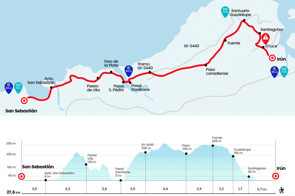
by km 0.Iron
We go out of the hostel, to our right where there is a rotonde, we take the GI-2134 direction Hondarribia for a few meters later to pass under the GI-636, we continue by the GI2134 to the end of a half kilometre to get to a great rotonda which we cross to continue in front and pass above a ría, nothing more to cross the bridge we have to turn to the left, eye here that the passage of cebra is a A little later, to take a pedestrian walk that at the beginning goes parallel to the ría and that then on the rise will take us to the ermita of Santiago.
3 km: Ermita de Santiagotxo
In the crossover of the ermita we follow to the left hand and as half a kilometer we take the way that rises to the Guadalupe Sanctuary. They are 155 meters of level and a little more than a kilometer. It is necessary to do the maximum because the stage is long and broken. In the last ramps you can already see the picky tower of this sanctuary that keeps the policromed size of the patron of Hondarribia. It is believed to come from the proa mask of some Basque ship. next to the temple there is a source (rece not suitable for consumption) and behind a bar-restaurant. Also behind, short distance from the sanctuary and outside the itinerary, there is an 1900 year strong (Km 4,7).
Km 4.7 Sanctuary of Guadalupe
The panorama is amazing, with an unbeatable view of the shore of Txingudi. On the other shore we see Hendaya and in our Hondarribia and Irun. next to the sanctuary we take a track next to Jaizkibel Forest House, the name of the mountain that we will border from now on. In short, after a few stairs, the road is divided into a couple of options: one for 'alpinists', more spectacular that goes by the high and follows the GR-11 (links about 3 km with the official itinerary) and the one of the pilgrims of all life. We passed next to a camoufled fountain with the registration Year 1940 (Km 6.9) and soon the track descends.
In this plot we may see some pottokas, a poni originating from the Basque Country. If the fall has rain, it can be scattered and the 'bicyclists' will have to carefully manage the successive curves. At the time we cross a Canadian step and turn to the right in direction of Pasaia (Km 9.8). The profile is somewhat broken for a couple of kilometers in which we will draw another Canadian stage. Afterwards, the track descends for many more kilometers by a beautiful mixed forest, exceeds the indication of Pasaia Donibane 3.4 km and reaches the GI-3440 (Km 14,2).
We take it in front, in ascension, and 150 meters after the 4 km point we leave it on the left. At this point the stage obsess us with a swallowed view in the V of the lighthouse and the insigned of Pasaia. The strong subsequent descent makes mella, the bag pushes forward more than it should and it is appropriate to let it be taken and not retain the inertia with the quadriceps, which will end painful. We enter Pasai Donibane through the Larrabide neighborhood and on the trail of stairs we find the left-wing deviation towards the Santa Ana hostel, for those who want to pernoct here. The rest continues to descend by the right to the houses and the boat. Pasai is divided into four districts: Pasai donibane, Pasai San Pedro, Pasay Antxo and Trintxerpe.
Km 16.7 Passai Donibane/Passage of St. John
Here we take a small motor for a modic price and save the scarce meters that separate us from Pasai San Pedro. After landing we head to the right, through the Torreatze street, and we go bordering the river to the sea and passing alongside a Maritime Cultural Center. We meet with a fighting trail of stairs that will make us endless if we start it with too much joy. Go out to the road of the Faro de la Plata and 150 meters before arriving in the building we move to the left by a coastal path in direction of San Sebastián.
Km 18,9 Faro de la Plata
This beautiful tour alongside the sea is quite waved.The ruins of an ancient waterway come out to us and in a dark hole we leave a small stone stone.The path leaves in the neighborhood of the Paseo de Ulía (Km 20,5).
We passed next to the number 375, where there is a community that welcomes the pilgrim and later we get to a parking area. Here is the deviation to the youth hostel Ulía, which is 150 meters away. Do not give dinners and is quite apart from the city. The road descends by an envy environment to a spectacular view of San Sebastian. In first term the beach of the Zurriola and the Kursaal and passed the desembocadura of the Urumea is appreciated the beach de la Concha and the Mount Igeldo. We still have a long and beautiful walk to the hostel. After the panoramic we turn to the right and descend bruscly to the street Zemoria of San Sebastian (Km 23,4).
Look at the signaling in the city, it's easy to go down. We continue down to the right by the avenue of Navarra and go out to the parallel walk to the beach of the Zurriola. There's little loss. We pass by the front of the Kursaal, we cross the river Urumea and do the same with the Alameda of the Boulevard (here's the Tourism Office). Remember that at the right hand is the old town of San Sebastian, where everyone should give a good round of paintings.
Km 24.8 San Sebastián (Municipality)
After the tunnel under the Miramar Palace we will see on the pass of pedestrians on the left some yellow flags (in pegatina). These orient towards the Ikastola Jakintza pilgrims hostel, managed by the Association of Friends of the Way of Guipúzcoa and which opens during the months of July and August. The signals take alongside a Bank of the People's Office and continue in front of the Matia Street until the cross with the Escolta Real Street.
The rest of months, if our intention is to sleep in the youth hostel La Sirena, we must go ahead behind the tunnel and pass through the walk a trail from the beach of Ondarreta. Then it turns to the left hand to continue in parallel through the avenue of Satrústegui and pass the hotel Ezeiza turns left to catch the walk of Igeldo.
Km 7th, 6th San Sebastian
Arrival and End of Stage